Grand Canyon – North Rim

THE OTHER GRAND CANYON

Grand Canyon, North Rim

Grand Canyon, North Rim

Almost everyone over the age of six has heard of the Grand Canyon and most upon learning about it wish to pay this national park a visit and for very good reasons. The immensity of the divide coupled with the charms of the southwest and the wide open skies draw the visitor in. It is gracious in its enormity.  But I know a secret. The vast numbers of yearly visitors, 4.5 million in 2013, tend to gather along the canyon’s developed south rim. This makes sense given the ease of access from several nearby interstates, fairly mild weather and even train service on the Grand Canyon Railway. But, on summer days this can make a walk along the popular sections of the South Rim something akin to visiting a shopping mall or a busy downtown avenue. While it is true that you can escape into solitude by being one of the less than 2% of visitors who venture into the back country; however, there is another way to enjoy the canyon with breathtaking views almost to yourself…visit the park’s North Rim.

DSCF1203 b

Grand Canyon, North Rim

You approach the North Rim from, well the north, after passing through the tiny resort area of Jacob Lake. It is just a 45 mile scenic drive to the park’s entrance from there. Once in the park you have the opportunity to visit quiet scenic pull-outs, enjoy plentiful wildlife and relax in the cooler temperatures that come with being 1000 feet higher than the South Rim. Visiting the North Rim does require some planning as it is not a day trip – unless the idea of driving throughout the night excites you. Lodging is available in either Jacob Lake (camping, cabins or lodge), at a few other camping facilities or within the park itself. There are only a small number of beds, camping spaces and cabins so its wise to book ahead.

Walhalla Ruins

Walhalla Ruins

The North Rim has many of the same activities of it’s southern cousin, hiking, horseback riding, ranger talks, souvenirs, mule rides, sunsets, sunrises, good eats, archaeology, history and a wonderful scenic drive, but with fewer people. Somehow the buttes and cliffs within the canyon seem closer. Perhaps it is that the air is a bit clearer higher up. But be warned, there is also less time to enjoy these activities since summer is short on the North Rim. The park usually opens to cars in mid-May and then closes again in mid-October when snow begins to fly. Winters along the North Rim can come with upwards of 12 feet of snow and access is limited.

Angel's Window

Angel’s Window

Regarding your time at the North Rim, I suggest using a good and recent guidebook to plan your drive and expeditions. Most books will advise you to drive the Cape Royal Road and I think it best to start this drive early in the day. First drive all the way to the end and start your viewing at Cape Royal. Catch the canyon in the morning for the best light and do take a walk out onto the peninsula and over Angel’s Window. On the way back there are plenty of chances to pull-out for a photo, hike or picnic. Be sure to bring something to eat and drink with you as there is no food available along the drive. Consider hitting the main visitor’s center or Jacob Lake’s store to stock up on lunch provisions. Stop and visit the Walhalla Ruins on your way back and then drive out to Point Imperial to top off your day. It can be magical along the rim at night with excellent star gazing, but watch for deer, elk and even bison when driving back.

There’s far more to write about regarding the North Rim experience and a small blog post cannot do it justice. I invite you to explore this lesser known region of the Grand Canyon National Park. It is only 3.5 scenic hours from Las Vegas and 3 hours from Flagstaff. Wonderfully not close any large city and beautifully located within some of the most inspiring landscapes in the world. Although the visitor center and lodge can seem crowded during the day due to the fact they are smaller than at most large national parks, the smaller crowds along the trails, roads and view points give the area a friendly appeal and set a relaxing tone. There are even rocking chairs placed outside on the main lodge’s patio for enjoying the view and getting to know your fellow visitors. Plus, when you tell your friends and family about your visit to this most famous national park, you’ll have your own secret to share.

Cabin at Jacob Lake

Cabin at Jacob Lake


Bryce Canyon National Park

WELCOME TO BRYCE AMPHITHEATER NATIONAL PARK?

Sunset in Bryce Canyon National Park.

Sunset in Bryce Canyon National Park.

When is a canyon not a canyon? When it is Bryce Canyon National Park. In fact this collection of hoodoos is composed of several amphitheaters that are slowly eroding from the main plateau. The southern reaches of Utah are laid out like a series of steps rising form the Grand Canyon on up to the Brian Head formation which is the top ridge that runs along Bryce’s formations. The formations themselves are carved from the iron rich Claron formation just beneath which gives them their beautiful red and orange colors.

Hoodoos in Bryce's amphitheater area.

Hoodoos in Bryce’s amphitheater area.

This is a national park that can be easily seen by car in a half-day or explored for many days on foot. Making up one of the “Big Five” parks in southern Utah (Zion, Bryce, Arches, Canyonlands and Capital Reef), Bryce is probably the highest in altitude at between 8,000 and 9,000 feet. This makes for cool evenings and mornings and pleasantly hot summer days  interspersed by snow storms through the winter. The flora and fauna change subtly as you rise from the park’s entrance and up along the ridge. The drive is an out-and-back affair with scenic views all along the way. Be sure to pack a lunch and enjoy a picnic or stroll along one of the many hiking and nature trails.If you bring a camera, and who wouldn’t to such a park as this, be sure to head out early to catch the sun’s rays as they warm the red stone. Sunset is also a good time to see the changing colors of the hoodoos although expect to share it with an appreciative group of viewers.

Cabins in nearby Tropic, Utah.

Cabins in nearby Tropic, Utah.

You can stay in the park (camping or in the lodge) or just outside the park in the “town” of Ruby’s Inn (again camping and hotel options are available). The Ruby’s Inn area has everything that a tourist needs, including lots of other tourists, but it has a sort-of festival vibe to it and despite the tour buses and a plethora of RV’s, everyone is friendly and happy to be there. I never sensed the urban-like pressure that sometimes seeps into Grand Canyon’s Tusayan area. There are other lodging options as well. We stayed in the nearby town of Tropic which was much quieter, but with fewer tourist services available. There was a definite sense of pride in the little town’s heritage and we did find a local coffee house and access to local brews at nearby restaurants so it was well worth the ten minute scenic drive up to the park. We found the Bryce Canyon Inn in Tropic to be comfortable and well run with like-new cabins.

Opportunities to hike into the hoodoos and explore abound throughout the park.

Opportunities to hike into the hoodoos and explore abound throughout the park.

There’s no secret to visiting Bryce other than getting an early start, like all major national parks, and picking up a good guidebook to help you sort our your hikes and other activities. We found Moon’s Zion and Bryce guidebook (which also includes the other big five parks and areas of interest in southern Utah) to be very handy and accurate. While the park is not close to any major cities and may seem very rural to those who are not used to the wide open spaces of the Southwest, you never really feel  way out there as there are plenty of small towns and communities usually within twenty miles or so of each other. Still, it is always a good idea to top off your gas if you are going exploring. And there is a lot of exploring to do. Even the drives between the parks are scenic and offer many opportunities to see and learn and there is a wealth of state parks and national monuments to enjoy as well.

Walking up to Mossy Cave.

Walking up to Mossy Cave.

Outside of the main section of Bryce just off of Highway 12 between Bryce and Tropic is a wonderful little walking trail, Mossy Cave. This path follows a small creek leading up to a modest waterfall and, you guessed it, a mossy cave. This is great walk in the morning and good for those traveling with children or who may have trouble hiking at this altitude as it is a short gradual climb and the trail is well marked.

Whether you are looking for an adventurous hike of several days or a leisurely drive to visit scenic overlooks, Bryce Canyon (amphitheater) National Park will not disappoint. Be sure to add this to your list of parks to visit in the near future.

The Hunter hoodoo formation.

The Hunter hoodoo formation.

Oregon’s Painted Hills

THE HILLS ARE ALIVE, WITH THE SOUND OF COLOR

Red Hill

Red Hill

I was originally going to start this post by referring to Oregon’s little painted desert, for the actual size of the Painted Hills unit of the John Day Fossil Beds National Monument is not very large when compared to the closely named National Park in Arizona. Yet, when you take into account the huge size of the clay deposits that make up the beauty of these hills, it’s actual size is in fact astounding. For most of my ride home to Boise, at least for about 200 miles, I continued to run across similar clay formations all of which began long ago as ash deposits from ancient volcanoes.

Near Sheep Hill

Near Sheep Hill

Although you see hints of the colors of these hills as you enter the picturesque Picture Gorge just outside of the John Day Fossil Beds National Monument, it is not until you reach the visitor’s center that you begin to see the true colors of the area. Stop here first to get information on the area and to visit the excellent Thomas Condon Paleontology Center. Although there are no dinosaurs in these extensive fossil beds, you will see evidence of primitive mammals that are both strange and wonderful.  After leaving the visitor center, you turn

Blue Basin

Blue Basin

north onto Hwy 19 (left) and in a few miles you come to the Blue Basin area in the Sheep Hill Unit. All of the hills in this area are in several shades of blue and green. The intensity of their colors depends on the time of day and if they are wet or dry. You can hike the slightly strenuous Blue Basin Trail and will be rewarded with a superb view of the surrounding area. There are also fantastic views down into a steep gorge which seems to shimmer with subtle blues and grays several hundred feet below your boots. The trail is dog friendly, but young children will probably tire out before reaching the top of the loop.

The next stop on our tour is back the way you came, past the visitor’s center and then west (right) onto Hwy 26 for about 30 miles to the Painted Hills Unit. The area is well signed, as are all of the trails and points of interest in the national monument, and you will travel on well

Painted Hills

Painted Hills

maintained gravel roads throughout the unit. This area contains the postcard views of the monument and all are easily seen from the car or along short walks. Some areas provide boardwalks so that you can get close up to the formations, but please do not walk on them as they easily mar and it takes time for them to self repair.

These hills get their colors from clays that are themselves altered ash deposits from volcanic eruptions that occurred millions of years ago. The different colors come from differing chemical make up of the clays and truly do vary by the hour as the sun and clouds partner to change the hues. Any time of day they are beautiful, but if you can swing a visit at sunrise, they truly “pop”. I was there for both sunrise and sunset and I saw no one all morning. I enjoyed the solitude. The hills themselves

Only a hardy few can make a go of it on the clay surface of the hills.

Only a hardy few can make a go of it on the clay surface of the hills.

can appear a bit lonely as most are completely without vegetation. Only a few hardy plants can find purchase in the clays the material self-seals when wet, preventing roots to penetrate and sloughing off surface material. But for those few that do make it, they add a lovely touch of green to the heavy reds and give some areas a bit of a Christmas feel.

Along the edge of the hills various sagebrush desert plants can be found and the area’s rivers provide comforting shade in the riparian areas. If you look around while you hike you can find all kinds of other colors. This is probably more true in spring since summer is likely to be dry, hot and the flowers fleeting. I’ve never been in summer, so if

Hardscrabble Beauties

Hardscrabble Beauties

that’s the only time you can get there, by all means do go, but plan to get out at sunrise and sunset to fully enjoy the colors and save the hot afternoon for the visitors center.

Painted Hills Close Up

I found this area map to be very useful and accurate. The area is rural, but it’s nothing like other parts of Oregon or the West which can feel practically deserted. But beware, there is no fuel available in the town of Mitchell and Oregon is only one of two remaining states that do not allow you to pump your own gas. You may not be able to fuel up at 5:00 in the morning or in the middle of the night unless you are on a major interstate or near a large city (which in this area you are definitely not). Still, with careful planning you will be fine and your only concern may be finding a bathroom. There are not toilets at many of the trailheads, but you will find them at the visitors centers in both the Sheep Hill Unit and the Painted Hills Unit and at Blue Basin. The monument’s web page has information on directions and lodging and the map above shows several camping areas and primitive spots where camping is permitted. I stayed in Priest Hole (a mountain man’s term for a valley) and enjoyed a riverside spot and great sunset views. Some of the roads outside of the monument may require high clearance vehicles and four wheel drive if it is at all wet and may not accommodate RV’s or trailers. You can check with the visitors centers for more information on the area’s amenities.

Bring plenty of snacks and drinks and enjoy some picnics at these scenic spots and don’t forget your camera.  Even when it is completely quiet, you will find that these hills sing and they are waiting for the intrepid traveler to come see and hear them.

Priest Hole along the John Day River

Priest Hole along the John Day River

Pillars of Rome

WHEN IN ROME

Oregon's Pillars of Rome

Oregon’s Pillars of Rome

About 3 miles off of Highway 95 near the community of Rome, Oregon resides the stately rock formations known locally as the Pillars of Rome. I can only assume that the pioneers who first wandered along this area saw in these eroded formations some resemblance of the Roman temples and buildings of yore. These lovely cliffs are up to 100 feet high in some places and the formation is about 5 miles by 2 miles in size. It sits along the old stage coach/highway that runs through Malheur County.

Pillars of Rome

Pillars of Rome

As with most rock formations, especially those that are white and tan in color, the best time to visit for photographing is morning or evening, but anyone traveling this part of Oregon will enjoy this quick detour regardless of the time of day or year. They look to be made of the similar clays that run throughout this part of Oregon, remnants of ancient volcanic ash deposits. They are said to contain a large number of fossils and the cliff face hues change subtlety throughout the day with the tracking of the sun and clouds. If the weather is nice it is easy to walk around and take a closer look. Up close some of the hoodoos remind me of a miniature Petra, the ancient Middle-eastern city known for its rock architecture.

Remnants of the old stage coach route.

Remnants of the old stage coach route.

To get to the Pillars of Rome turn north onto Rome Road just outside of the community Rome (it is signed “Pillars of Rome” at the highway). Then turn right when you reach the Old North Highway and then left at Kiger Road (there’s another sign for the Pillars) and then drive until you begin seeing the formations. The first formations show up at about 3.2 miles after you leave Hwy 95. The road is well graded and wide. There are no signs nor facilities once you reach the Pillars, so it’s best to hit the restroom at the station in Rome before heading out. On the plus side, you will likely have the place all to yourself and in the silence you do indeed feel as if you are standing among classical ruins.

Pillars of Rome

Pillars of Rome

Idaho’s Initial Point

THE START OF IT ALL

Idaho's Initial Point

Idaho’s Initial Point

OK, so maybe Idaho’s Initial Point south of the small town of Kuna in south-central Idaho may not be the start of everything, but as far as Idaho geography goes, every point in the state ties back to this small volcanic cone in the middle of the Snake River Plain.

This rather nondescript hill sits anonymously just off of Swan Falls Road near the Swan Falls Dam on the Snake River less than an hour from Boise. There’s a small roadside sign at the turn-off and a graded road leading to the cone’s base. It’s open range country out hear so drive carefully. On one visit I had to drive around a dead cow, but assuming that you can stay on the gravel road a passenger car can make the mile long drive to the base of the crater with ease.

Initial Point IdahoAt the base of the hill you can follow a rough track to the viewing platform. It’s only about a ten minute walk up to the top of the hill which looks to be just over 100 or so feet high. Theoretically you could take a Jeep to the top, but what’s the fun in that? I left mine a the bottom and enjoyed the quiet walk up. I’ve never seen anyone else here, but there are usually shells and beer cans scattered about to indicate that this may be a bit of a party place at night. This year I found beads and a feather boa, so who knows what goes on up there when no one’s looking. Chances are if you go during the day you’ll have it to yourself.

Idaho's Snake River Plain

Idaho’s Snake River Plain

At the top there is a small viewing platform where you can get a great view of the surrounding plain and the neighboring mountain ranges – weather permitting. There is also a small unmarked cross that suggests a nearby grave, but I’ve never been able to confirm it. I still treat the area with some respect. Here is a BLM website with other history information.

Cross marker near the top of Initial Point

Cross marker near the top of Initial Point

There are several other interesting sights in this area such as the Swan Falls Dam and a super view of the Snake River Canyon from Dedication Point, but more on that later. If you can’t wait, you can learn more about this area from this Idaho scenic byway website.

Black Magic Canyon

A TOUR THROUGH EBONY WONDERS

Idaho's Black Magic Canyon.

Idaho’s Black Magic Canyon.

Far off of the beaten path, yet not that far away from paved roads lies a hidden gem in central Idaho, Black Magic Canyon. The canyon itself is small when measured by depth, but runs for several miles across the high desert and holds a wealth of beauty. A wonderful world of finely sculpted black basalt awaits intrepid visitors and once you find your way in, the exploration is easy and the sites addictive.

There is no easy way to find the canyon itself. There are no signs, so I suggest using the map supplied by the Bureau of Land Management as your starting point along with a current atlas of Idaho roads. When the road comes to a fork (350 E and 820 N), the more developed path turns sharply left. You will go down a slight hill to the right and cross a cattle guard. If you see a canal to your right and a shot up sign warning you not to take any rocks off of BLM land you are on the right path. Go about two miles down this dirt road and stop at the small diversion dam on your right. The road is fine for most cars and trucks, but beware of muddy conditions if there have been recent rains.

Wash basin hiding in the canyon.

Wash basin hiding in the canyon.

There’s noting much left to write about this canyon as it is best enjoyed visually. The Big Wood River has been hard at work carving out the beautiful formations throughout the canyon, so bring your camera and plenty of batteries. This area is dog friendly, but small dogs may have to be carried through some parts of the canyon. There can be water flowing through the canyon in the summer and it fills with snow and ice in the winter, so be sure to plan your visit accordingly.

DSCF0322 b

There is some color in the canyon, but most of the views are subtle blacks and greys.

DSCF0325 b

The canyon is easy to follow, but it may require some bouldering to get around larger rocks.

DSCF0316 b

A Zen moment in the canyon.

DSCF0304 d

The entrances into this shallow canyon only hint at the wonders ahead.

DSCF0314 b DSCF0309 d DSCF0308 b

Grove of the Patriarchs

SOAKING IN THE BEAUTY OF OLD GROWTH

Giant firs along the Grove of the Patriarchs Trail

Giant firs along the Grove of the Patriarchs Trail

One of the neatest areas at Mount Rainier doesn’t even have views of “The Mountain”. On the southeast edge of the park, just beyond the Stevens Canyon entrance on Hwy 123 lies the Grove of the Patriarchs. This is a wonderful example of Pacific Northwest old growth with huge hemlocks and absolutely giant Douglas firs. It’s an easy trail that even involves a swinging (slightly) bridge and convenient boardwalks that protect the trees vulnerable root system from the trampling feet of earnest admirers.

This is a short trail, unless you chose to start at the Laughingwater Creek trailhead or Ohanapecosh Campground. These will make for a longer, yet still pleasant walk. The brevity of the the trail invites a meandering pace and encourages stopping to stoop and smell the compost. Look carefully through the underbrush for fungi in all sorts of wonderful colors and shapes and notice how slowly the trees rot after falling.

A boardwalk protects the feet of walkers and the roots of trees.

A boardwalk protects the feet of walkers and the roots of trees.

Shortly after crossing the Ohanapecosh River on the suspension bridge you will approach a massive red cedar. Enjoy this view and then walk farther along the trail to witness huge twin firs and an assortment of other giants that only a regular visitor among giant sequoias would not find impressive.

Plan to visit this grove in the morning to avoid crowds or in the evening to enjoy the early dusk provided by your enormous hosts. If you are still up to it, you can leave the parking area and follow a nearby trail down to Silver Falls. Again, this trail is very popular so plan to go in the off hours for any degree of solitude, BUT, if you cannot go early or late, do visit each trail anytime you can as this is not a sight to miss.

The underside of a fallen tree reveals a starburst pattern and a shallow root system.

The underside of a fallen tree reveals a starburst pattern and a shallow root system.

An ancient nursery tree still nourishes younger trees many, many years after falling.

An ancient nursery tree still nourishes younger trees many, many years after falling.

Mount Rainier

VISITING “THE MOUNTAIN”

Mount Rainier above Reflection Lake

Mount Rainier above Reflection Lake

Most national parks in the United States beckon with the rumor of what lies ahead, a whispered promise of great glories. Often it is not until you near the edge of the Grand Canyon or enter the Geyser Basins of Yellowstone that you truly begin to appreciate the wonders before you. Mount Rainier National Park is different. On a clear day you can see the potential of that which awaits you from nearly 100 miles away. Whether you approach from Seattle or from the open plains of central Washington, Mount Rainier shines like a lamp lighting your way.

Subalpine wonder beneath Naches Peak

Subalpine wonder beneath Naches Peak

This trip to Mount Rainier, what I anticipate will be the first of several, focused on the eastern side of the park. One thing the visitor quickly appreciates is not only is this one big mountain, it is also one big park. At over 236,000 acres there is much to explore and most of this land is designated as wilderness. Due to the mountain that lies at the heart of the park, exploring by car necessitates driving around the edges. But with over 250 miles of maintained trails, its worth the extra time spent at the wheel.

The eastern edge of the park lies in the rain shadow of the mountain and as a consequence is drier. Much of the higher elevation areas resemble the mountains of the northern Sierras or the Rockies with multiple vantage points along the trails and ample room between trees for wandering. Along this side of the park running north to south are Highways 123 and 410. The largest attraction in the eastern portion sits near the middle of this byway, Sunrise. As its name implies, this is indeed a great place to catch the sunrise and on clear mornings early risers are treated to the alpenglow of what many refer to simply as “The Mountain”.

Alpenglow charms the viewer and frustrates the photographer

Alpenglow charms the viewer and frustrates the photographer

Other areas of note on this side of the Park are the superb hiking areas around Yakima and Naches Peaks along with the glamour of Stevens Canyon, pristine lakes along the Bench and the deepening radiance of the Grove of the Patriarchs where massive trees rise out of the ferns and moss to the delight of onlookers.

My  next few posts will focus on each of these areas in turn and logistics for visiting the eastern side of this wonderful national park. Hopefully I can light a spark for those who have never visited this park or rekindle one for those who would like to return one day.

Multiple rivers get their starts from the glaciers of Mount Rainier

Multiple rivers get their start from the glaciers of Mount Rainier

Crater Lake’s Pinnacles

CHIMNEYS OF STONE

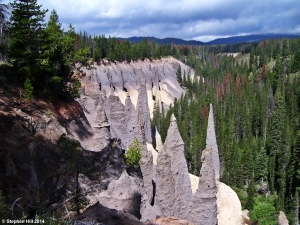
Chimneys of stone await visitors at The Pinnacles.

Chimneys of stone await visitors at The Pinnacles.

One of the lesser known attractions of Crater Lake National Park is The Pinnacles, an area located at the end of a road called, what else, Pinnacles Road. Perhaps it is because the area is at the end of this road after a 7 mile drive with only a campground on the way to look at and nothing else but trees to enjoy. But patience is rewarded when and in a few miles beyond the campground a narrow canyon begins to run parallel to the road and then you see them, great towering chimneys rising up from the side of the canyon like rounded skyscrapers or fantastic castle towers. Your view is from the rim, so you are looking down on them like an airplane flying over a great cityscape.

The Pinnacles themselves are actually ash that was welded into place by a chemical reaction as steam and hot gases continued to rise up through the earth after the initial eruptions of the volcano Mt. Mazama, Crater Lake’s ancestor. Ash once filled this canyon to overflowing, but only the hardened chimneys remained behind after erosion carried away the lighter ash that surrounded them. The result is a remarkable testament to the power of chemistry and erosion and it is surprising that the area is not more popular than it is.

Stay for a bit and drink in the colors of the canyon.

Stay for a bit and drink in the colors of the canyon.

You can see several groups of towers from the parking area, just a few feet from your car in fact, but the best way to experience them is to walk south down the nearby nature path that runs along the canyon’s edge. As always, keep a close eye on kids and your footing as the edge of the canyon is crumbly and dangerous. I found the unofficial overlooks along this trail to be a great spots for lunch and if you can spend about an hour here you can see the colors of the canyon shift as the sun passes overhead. Are you visiting on a cloudy day, well then you can expect the colors of the canyon to pop in your photographs, especially if its just rained a bit. If the road is open, then there is really no bad time to visit. Come and enjoy this sight as the more popular ones along the rim of the lake grow more crowded during mid-day.

The one-time southern entrance into the park.

The one-time southern entrance into the park.

The nature trail continues downstream along the canyon’s edge for about a mile through a pleasant young forest. It ends at a forest service road, one of the original entrances into the park. The sign post remains and with a careful eye you can just about see where the old road ran on its way up to the main attractions. At one time The Pinnacles was a favorite stop, perhaps the first stop for most visitors during the entrance’s heyday. Now it can be your little secret to enjoy in relative privacy. Enjoy, but try not to be too smug when you return to the more crowded viewpoints above the lake.

Crater Lake Trails

OFF THE BEATEN PATH

Many who venture to Crater Lake National Park only come for the day which still makes for a superb visit. But there is so much more to see on the leeward side of the caldera. Some of the best trails in the park do not have views of the lake. Here are three of my favorite trails. Check your guide book or the park map, available at the gate, for more detailed driving directions.

Wildflower wall beneath Castle Crest.

Wildflower wall beneath Castle Crest.

Castle Crest – Starting from the Steel Visitor Center simply cross the road to enjoy a quiet stroll in an old growth forest. After about .4 miles you will join a wildflower loop after crossing the Munson Creek. This part of the trail loops along a “weeping” wall of wildflowers and moss covered stone. July seems to be the peak of the most colorful flowers, but late June and early August should also be good times to catch the wildflowers in costume.There is a parking lot at the start of the wildflower loop for those looking for a shorter walk. Pamphlets describing the various fauna are available at the beginning of the loop and following the loop to the right allows for the flower wall to sneak up on you, adding to the sense of wonder. Take a moment to savor the smells of the plants, the hum of insects and the vision of darting hummingbirds.

Watch for water ouzels at Plainki Falls.

Watch for water ouzels at Plainki Falls.

Plaikni Falls – The park’s newest trail wends through a pleasant forest and terminates at the base of a lovely 20 foot waterfall. The trail is easily accessible and starts at a parking apron one mile along Pinnacles Road. Sand Creek flows from the falls and works its way through a nice little canyon that seems to be at your feet as you view the falls. The forest has very little undergrowth which makes the trees seem even bigger and on a hot day this can be a cool walk and has only moderate elevation gain. On my last visit I saw water ouzels, or American dippers, flitting in and out of the falls’ cascades as they fed on insects in the chilly waters. I have read about these birds numerous times in the works of John Muir so it was wonderful to finally see them in “person”.

Steep canyon walls await visitors to Godfrey Glen.

Steep canyon walls await visitors to Godfrey Glen.

Godfrey Glen – Another easily accessible walk, this one meanders through a thick conifer forest and then along a steep canyon carved into the hardened ash and pumice. The trailhead is about 3/4 of a mile south of the visitor’s information center. Munson Creek has helped to carve this steep sided canyon and plant a verdant glen of trees along the creek banks. Watch your step when near the edge and keep children close since the sides of the canyon can be crumbly and there is not much to stop a falling hiker except for the bottom. The return loop is more views of the forest, so you might want to do this one as an out-and-back hike along the canyon. This trail gives you a sneak peak at the wonders of The Pinnacles which I’ll blog out next, mysterious stone chimneys.